

The state policy, which provides for the introduction of new programs to stimulate the development of renewable energy, provoked a real boom in the erection of the FES. The construction of photovoltaic stations is mainly carry out by the company EPC (in translation from English Engineering, procurement and construction – construction on a turnkey basis). Now popularity is gaining construction work performed independently by the customer or contractor. It is important for photovoltaic stations to ensure an appropriate level of service and quality service.
Television shooting of solar panels and related equipment is still the most common way of servicing. Thanks to such a survey, it is possible to create thermal images that will allow a specialist to draw a conclusion about the correct functioning of the FES.
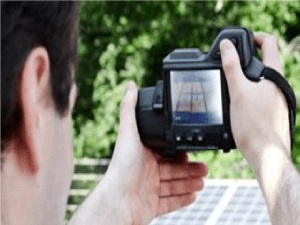 In addition, thermal imagers can inspect photovoltaic stations. Such a study is do manually. The operator must bypass the entire station to inspect each solar panel with a fixing device. Further, analytical work is carry out on the images obtained and a conclusion is make in the form of a report that determines the satisfactory operation of the FES or the availability of any service cases.
Now, in our country, FES services are becoming increasingly in demand, even companies that only deal with service issues appear. However, some companies in tandem with customers, trying to save a small part of the money, eliminate the need for planned research. This leads to even greater costs when the FES goes out of order and requires serious repairs.
How to conduct research-using drone?
Drones are unmanned flying devices that can be control via Bluetooth. Now drones are attracted to the FES survey, since aero technical survey by these devices is safer compared to the survey in manual mode (the probability of electric shock is exclude). In addition, the drones take pictures in less time and show greater efficiency, and sometimes – save money, because a FES survey in this format is cheaper.
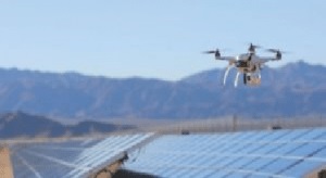 To compile a full report for a 1 MW photovoltaic station, the drone will need only 1 working day. The localization of deficiencies is reveal within a few minutes. A drone’s survey of a 200-megawatt station can do in 6 hours.
Unmanned devices can use:
– service-servicing companies (for the purpose of carrying out a planned survey, carrying out analytical work to find shortcomings in the work of the FES, when taking the station to work from the customer)
– general contractors at the time of the transfer of the object to the customer or acceptance of the work of the contractor;
– customers for the purpose of accepting the work of the contractor or when servicing.
To organize a survey using drones correctly and safely, the following recommendations should be take into account:
- First, you should check whether you could use drones in the established area. First, it is necessary to analyze the objects nearest to the FES. If there is an airport nearby, a military base, a commercial facility, then the flight is possible only with the prior approval.
- It is necessary to plan the flight scheme of the drone through the software.
- Be sure to plan the height to which the drone should climb.
- Special attention should given to compliance with safety regulations.
- To conduct routine surveys, you must select satisfactory weather conditions.
- Avoid glare from the FEM – this can lead to errors in the interpretation of images.
- It is important not to exceed the flight speed, because the image will be blur.
- Checking the quality of shooting should done immediately on the site.
The newest method of servicing with the use of drones significantly expands the possibilities and saves time. In addition, such indicators as speed and quality of service are significantly increased. This method is most relevant for large industrial FES, since other methods of research of such scales can take several weeks. It is still not know exactly, will receive a wide distribution in our state, but I very much hope that this will happen in the near future. Currently, the Energy of Nature team – Green Tariff “is already conducting research data on FES with the use of drones. For more information, see the link below https://www.facebook.com/zeleniy.tarif/.
